The current aid effectiveness debate largely relies on cross-national evidence. This post introduces an innovative measurement technique to evaluate sub-national aid effectiveness. I introduce night light intensity as a measure of the relative level of economic activity in an area, and combine this dataset with a comprehensive geocoded aid dataset, which makes it possible to undertake a first-of-its-kind spatial analysis of aid effectiveness.
Disaggregated datasets
Light intensity from towns in Malawi was measured using stable night light images taken from the Defense Meteorological Satellite Program-Operational Linescan System (DMSP-OLS). Using these images, one can observe towns in Malawi that emit light, and measure changes in the light intensity from year to year. A proxy for economic activity was created by aggregating night light intensity pixels in every town in the country for each year between 2005-2010.
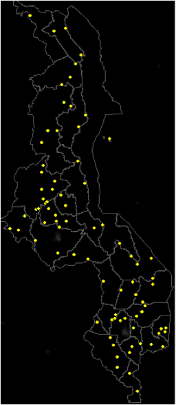
Figure 1: Night light cluster locations between 2005-2010
Yellow dots are centered on the brightest pixel within the night light cluster.
Note that both Lilongwe City and Blantyre City are excluded.

Figure 2: Geocoded aid project locations
Green dots represent geocoded aid projects in Malawi -- 2,113 in total.
Note that one green dot can represent multiple aid projects.
The earliest aid project start date is 1998 and latest aid project planned finish date is 2016.

Figure 3: Aid and night light locations
The stable night light images were overlaid on the geocoded aid projects using ArcGIS10.
This combined map enables analysis at the subnational level.
Note that the North of Malawi has fewer aid projects than the South.
In addition, there are more towns, as indicated by the prevalence of night lights, in the South.

Figure 4: Aid project locations within the night light cluster
F16 2005 stable night lights, Mzuzu, Malawi. 33.592 and -11.89 decimal degrees.
Only aid projects within the grid are included in the sample.
The 21 x 21 grid is centered on the brightest pixel.
In addition to analyzing night light intensity and aid within each 21 x 21 grid, analysis is conducted between each grid to provide a spatial component to the research.
Rainfall in Malawi is highly variable, and is one of the main factors driving variation in agricultural productivity. Therefore, a precipitation control variable was also created. Malawi’s rainfall data from 2005-2010 are publicly available from the World AgroMeteorological Information Service for the October to April growing season. These data are available for multiple weather stations in Malawi. Using Google Earth, each weather station can be placed in a district, and allocated to a town.
Results and conclusion
Both a random effects panel model and a spatial dynamic panel model were applied to the data. Aid's impact on economic activity, as captured through the degree of night light intensity, is somewhat sensitive to the type of econometric technique employed. Nevertheless, completed aid projects have a statistically significant, positive impact on night light intensity in a town. With these data, I also identified a negative spatial correlation for night light intensity between neighboring towns, which suggests that some form of mobility exists with regards to commerce or resources: positive shocks in one location are associated with negative shocks in surrounding locations.