Geospatial Database Analyst Albert Decatur worked with Kathmandu Universityand civil society organizations in Nepal this July to visualize development problems and projects using geographic information software (ArcGIS) from Esri. Decatur’s five-day ArcGIS workshop was an important part of the AidData Center for Development Policy’s efforts to mobilize local demand among Nepali institutions to use geospatial data and tools to track, deliver and evaluate aid more effectively.ArcGIS software enables any user to overlay different datasets and plot that data on a map to see the where development projects are located relative to areas of greatest need. With such visualizations, civil society organizations can better inform their local governments of shortfalls in service delivery or plan future projects to remedy gaps.During his five-day GIS workshop, Decatur instructed 16 participants from Kathmandu University and various civil society organizations, including: the Center for Environmental and Agricultural Policy (CEAPRED), Transparency International – Nepal, Open Nepal, and the Center for Policy Analysis and Development(CPAD). The training, hosted at Kathmandu University, included both lectures and practical lab work designed by AidData.“The main purpose of the trip was to build geospatial capacity of local partners so that they could make better [integrate] our datasets and [with] their datasets to answer questions that are important to their country,” Decatur said. “We imagined this workshop as the minimum that you have to train someone in GIS for them to start learning on their own. That is how we plan to build capacity.”
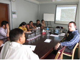
Photo: AidData's Albert Decatur (right) trains Nepali civil society leaders in ArcGIS. Photo contributed by Madeleine Clark. Decatur discussed with local civil society organizations ways in which they can use geospatial technology to map information on development indicators or project activities, tell stories with maps, and identify development questions that can be informed by geospatial information. For example, CPAD, one of the organizations that participated in the workshop, wanted to use GIS technology to mitigate devastation from landslides.“There was a JICA (Japanese International Cooperation Agency) highway built, and CPAD wanted to map the most likely landslide spots along that highway,” Decatur recalled. “Topography elevation is a major issue in Nepal. Everything is on an elevation gradient.”With GIS training, CPAD staffers can now use the ArcGIS technology to pinpoint exactly where the highway is on an elevation gradient in order to predict and better prepare for landslides.In providing training and building connections in Nepal, Decatur worked closely with four AidData Summer Fellows embedded in organizations in Kathmandu for the summer. Before they departed for their summer in Nepal, Decatur gave the fellows a one-week GIS tutorial. According to Decatur, the groundwork laid by these fellows to mobilize interest and commitment by Nepali institutions to use geocoded aid information surpassed his expectations.“There were four fellows working in three different organizations – Carleigh Snead and Sara Rock at Kathamandu University, Madeline Clark at CEAPRED, and Mike Hathaway at Transparency International – Nepal. They all did very different work depending on the organization,” Decatur said. “They took my GIS workshop and started teaching GIS workshops on their own to Kathmandu students and to CEAPRED staff, showing them ArcGIS and making those organizations’ datasets geospatial.”Decatur plans to continue working with these organizations and provide geospatial consultation remotely now that he is back at AidData’s College of William & Mary campus. “We made a lot of progress with each organization. As we start stretching out everywhere, we are forging a lot of meaningful connections and great partnerships that can go in a positive direction,” Decatur said.