One of the purposes of the International Aid Transparency Initiative (IATI) was to make information about aid not only more transparent, but easier for stakeholders in developing countries, and elsewhere, to actually use. Geocoding is one of the most exciting developments in this regard, meaning aid money can be traced to a close approximation of where its ultimate beneficiaries will be. The African Development Bank (AfDB) has been asked to guest blog for Development Initiatives (DI), with an update on the geocoding project they are undertaking with the support of AidData. We hope this inspires other publishers to explore the benefits of geocoding their IATI data.
The African Development Bank (AfDB) has proved its commitment to transparency by joining the ranks of over 190 development organisations which are publishing data to the International Aid Transparency Initiative. It has been ranked 7 out of 67 donors by a report from Publish What You Fund (PWYF) released on October 24, 2013. This ranking places the AfDB as second Multilateral Development Institution (MDB) just after the International Development Association (IDA) of the World Bank Group.
Overall, it is the highest scoring International Financial Institution (IFI) and regional development bank. Having disclosed data on both its public and private sector activities as well as providing precise geocoded information, the AfDB has also developed its disclosure and access to information policy. Effective since February 2013, this policy will help it prove its commitment to transparency in carrying out its projects.
This blog, a guest post by Sohir Debbiche, gives some insight into one of the major aspects of the AfDB’s new focus on transparency: geocoding. What is geocoding, why is the AfDB doing this, and how is it being implemented?
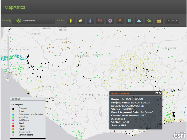
MapAfrica: Geocoding for greater accountability
As most of DI’s readers will know, geocoding (turning the location of development activities into coordinates that enable accurate placement on a map) has long been high on the agenda for those interested in the traceability of funding for development projects.
With this objective in mind, the AfDB is geocoding its entire portfolio of activities, by mapping the exact location of the operations on the ground. This will also help the institution better integrate its actions with other national open data and geospatial initiatives, principally the Open Aid Partnership, USAID and AidData.
In doing so, it will also improve the AfDB’s ability to invest in areas where actions are most needed. Today all active projects approved between 2002 and 2012 have been geocoded (with the exception of budget support and institutional strengthening projects (ISPs)) and the geocoding of 2013 projects is currently underway. This means 575 operations and 5600 project locations are now geocoded.
Being able to understand which projects exist, where gaps are, and who is working on what to address these gaps, will help all parties make more informed choices. For example, overlaying planned interventions with open data from governments, other donors, researchers, or NGOs on population, poverty, disease, or other indicators will help to better target, and also better measure, results.
Geocoding also offers a powerful tool to close the feedback loop, by allowing beneficiaries to share their views on the success of the operations. The AfDB plans more civil society engagement in its efforts for more accountability to stakeholders, and to gauge the effectiveness of their projects, for example a beneficiary engagement project, in which stakeholders will be able to provide feedback by clicking on a project location on the MapAfrica platform.
We hope to roll out this beneficiary feedback pilot in approximately one year, and hope this learning experience will result in improved decisions and better project outcomes.
How is the geocoding being done?
The AfDB worked with AidData to geocode its project locations according to the IATI 1.03 standard. The geocoded data were created using the AfDB’s portfolio portal and project documents, which were processed by AidData researchers using a methodology which includes strict quality control measures.
The location references were pulled from Geonames.org, a geographical database, and were joined to administrative boundary files for each country allowing data users to have not only the point data, but also the administrative regions which govern each point. The data were then merged into the AfDB IATI feed for publication.
Currently, the AfDB and AidData are working together to integrate geocoding into the Bank’s internal reporting systems, ensuring that data can be sustainably geocoded and reported to IATI by its project managers.
Feedback from partners has been positive but numerous challenges remain. As with other organisations publishing a large amount of IATI data, one high priority is in strengthening systems and tools to make transparency part of the institution’s way of doing business. Reforms are already on-going as part of the broader results agenda at the AfDB.