
Students participate in Mapping for Nepal event at the College of William and Mary in April, 2015.
On April 25, 2015, a 7.9 magnitude earthquake struck Nepal’s Gorkha district, inflicting massive casualties and damage. An estimated 8,600 people have been reported dead, 22,000 injured and hundreds of thousands displaced. In response, hundreds of millions of dollars have been mobilized to support relief and reconstruction efforts, ranging from the supply of tents and tarpaulins, to the deployment of aid workers and rescue teams. Yet, the timely delivery of assistance to the worst affected areas was (and still is) threatened by Nepal’s mountainous terrain and poor road infrastructure. So, how did open data help in this effort and what lessons were learned along the way?
Data Signposts for Disaster Response
Real-time information on the locations of damaged buildings and affected communities is not a panacea, but it is certainly critical to effective disaster response. In the aftermath of the Nepal earthquake, hyper-local, crowdsourced data functioned as signposts for both national and international organizations as they sought to provide timely relief to those areas in greatest need of assistance.
In the hours and days following the April earthquake, scores of actors in Nepal and around the world mobilized to put open source mapping to work in support of the relief efforts. AidData staff and students based at the College of William & Mary embarked upon one such collaboration in response to direct requests for data from development partners on the ground in Nepal, such as USAID’s Office of Foreign Disaster Assistance, among others.
In a student-led effort, approximately 60 students were trained to help provision information relevant for the disaster relief effort, contributing to crowd-sourced efforts on OpenStreetMap and the Tomnod satellite damage reporting system. Further, efforts were quickly undertaken to integrate and geocode YouTube videos, news reports from damaged areas, and NASA damage estimates. With support from Tomnod, the USAID Geocenter, ESRI, and CartoDB, this geo-referenced data was packaged and delivered in near real-time via an online portal to assist on-the-ground relief efforts.
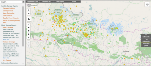
AidData’s Nepal Information Portal delivers hyper-local disaster data from news reports and YouTube videos
Food for Thought: Lessons Learned from Nepal
The path to reconstruction for Nepal is still long, but it is not too early to begin thinking about the lessons we learned in providing a “data response” in support of relief efforts on the ground. While the ultimate impact of these efforts won’t be visible for quite some time, we outline a few early stage lessons below:(1) Be creative. Disaster data can be useful to a wide range of actors, provided that it is available in a timely fashion. Think broadly about the types of useful and relevant data that you can produce - and do it quickly.
(2) Be usable. Satellite data can be difficult to use if you don’t have the right tools at your fingertips to effectively interpret the data. AidData’s online portal is one such tool, but even that platform posed difficulties in being able to integrate and readily display a variety of data in an internet-poor scenario.
(3) Be humble. In the aftermath of the earthquake, a multitude of organizations within Nepal and around the world sought to improve information flow for relief efforts by providing a variety of different data portals. Don’t get caught up in being part of the fray, but instead respond to direct requests for assistance. Don’t step on anybody’s toes, especially those who are working in-country to provide much needed relief.
(4) Be resourceful. AidData’s Nepal Information Portal would not have been possible without the help of students at the College of William & Mary. Within the first week, AidData staff and students held trainings for more than 60 students to support the disaster data collection. Leveraging the power and “wisdom of the crowd” can help make fast headway on critical data challenges.
(5) Be instructive. Students are a frequently untapped resource in addressing data shortages in times of disaster. With the right training and guidance, these young people can help quickly scale data collection efforts. When timeframes are tight, offering both video tutorials and short in-person trainings are relatively low cost ways to provide students with the necessary skills to contribute effectively.
(6) Be realistic. Data is useful, but it is not a panacea. It is not a substitute to effective on-site disaster response and relief. It is one part of a larger toolbox to quickly and efficiently tackle significant obstacles due to limited information.
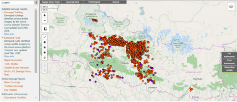
Satellite damage reports of damaged buildings and roads on AidData’s Nepal information portal.
Adding Value to Disaster Efforts with Data
There has been a groundswell of effort fueled by the work of many different organizations around the world to provide data support to disaster responders in Nepal. But there is still much room for improvement if this data is to be relevant, timely and useful to those who need it most. It is not enough to help - but to do so in ways that add the most value. So, what does this mean for the future of “first data responders?”
Rather than waiting until a crisis erupts, the open data and humanitarian assistance communities could be more proactively drawing upon past data trends to anticipate future disasters. “Earthquake info Portals” should not have to be built by organizations at the last second, but rather should already be ready-to-go in the face of hazards that are likely to occur. The responses to the earthquake in Nepal point us to the value of data in guiding decision-making, as well as the opportunities afforded by high concentrations of eager and readily-available individuals to collect that data. It is never too soon to begin reflecting on how best to apply these lessons learned in future efforts.

