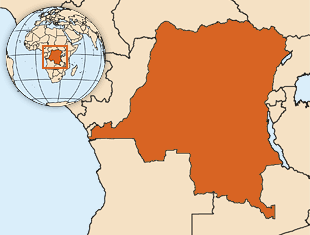
In November 2011, the people of the Democratic Republic of the Congo (DRC) voted in their second national election since the country declared independence. In the same year, the United States alone contributed about $1 billion in foreign assistance to the country. While the elections in 2011 were a step forward, 54 armed groups remain active in the DRC’s eastern provinces. With a population of over 65 million and large amounts of foreign aid being spent in-country annually, the Government of DRC has consistently emphasized the importance of using a manageable aid tracking system to monitor foreign assistance and ensure that resources are allocated to the regions, projects, and people that need them most.
This year, in partnership with USAID’s Higher Education Solutions Network, AidData will be supporting the Ministry of Planning within the Government of DRC to geocode all active foreign aid projects in the country. The resulting data will then be made publicly accessible through the government’s Platform d’Aide et des Investissements (PGAI). Last month, AidData team members visited the DRC to help kick off the geocoding operation, meeting with government and development partners to lay groundwork for the coming months of data collection.

The launch of geocoding work in the DRC is timely, as government ministries and development partners have repeatedly emphasized the need for geographic data on foreign aid investments, and for those data to be in a common format and central location. To reinforce the perceived appropriateness of the PGAI as that central location, the AidData team worked with the government to prepare project portfolios and partially complete data collection templates for each partner based on PGAI data. This exercise clearly demonstrates that the data within the PGAI are accessible, well managed, and are being used by government staff. This effort will also minimize duplication efforts for partner staff.
The DRC presents a challenging context for collecting aid information. It’s vast - the size of Western Europe - with dispersed and disconnected infrastructure. A country with strong provincial independence, most of DRC’s provinces are unconnected due to a lack of reliable roads. The DRC also frequently receives aid in the form of short-term contracts that involve diverse implementing partners. As Lisa Sthreshley writes in an article for the Pulitzer Center, “Donors influence not only what aid crises NGOs choose to address and who they try to help, but also where NGOs work. There are over 80 international NGOs located in the South Kivu province of Congo alone.”
While these circumstances make data collection more time and resource intensive, they also add a new dimension to the work that AidData is supporting. Given the fragmented nature of the DRC’s foreign aid community, the volume of support that the DRC receives, and the sheer geographic scale of the country, it is an environment where mapping foreign aid spending is of critical importance. With the ability to visualize who is funding what and where in the DRC, government, donors and civil society actors will have the information they need to reduce duplication of efforts, identify gaps in coverage and monitor results. In the coming months, AidData staff will work with our counterparts within the government and the development partner community to make this high stakes work a success.
Check back with us for updates and lessons learned as geocoding work progresses in DRC and beyond.
