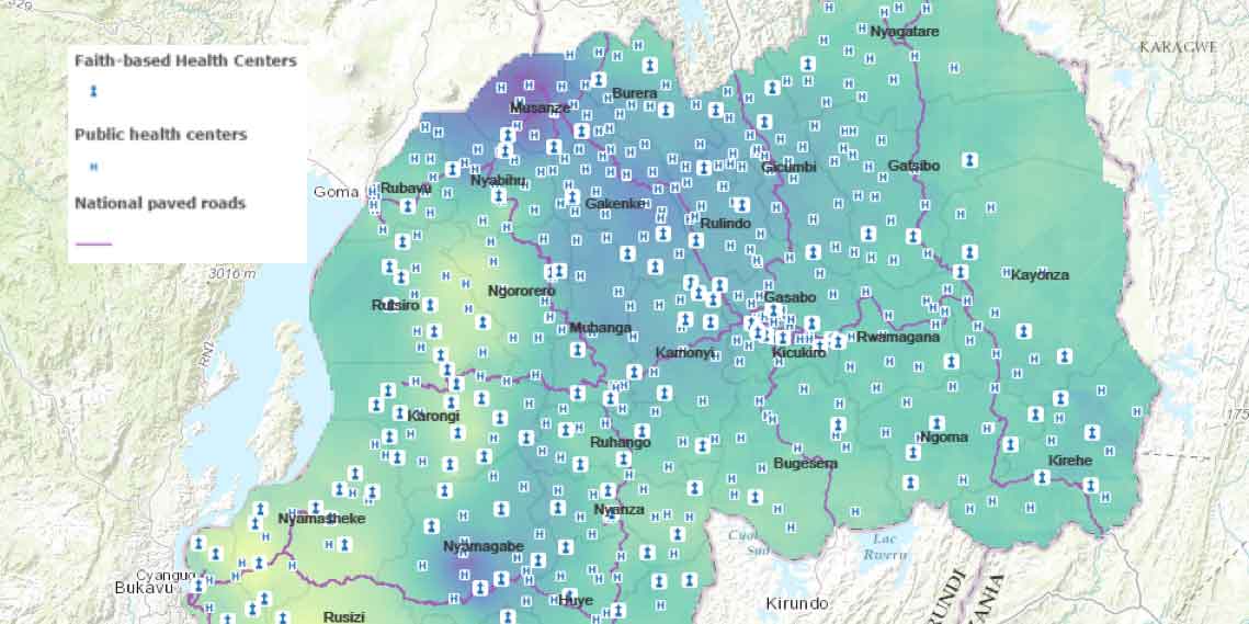
As part of its mission to prevent the spread of HIV/AIDS and improve health services, USAID/Rwanda needed to understand where in the country people were using contraceptives, and where they were not. The Mission wondered whether proximity to certain types of health centers — secular district hospitals, local faith-based health centers, or district hospitals with a faith affiliation — influenced the rate of contraceptive use among the population.
USAID/Rwanda tasked AidData Fellow Joshua Okafor, supported by GeoCenter researchers, to find out. After merging geospatial data on the locations of hospitals and health centers and their accessibility by roads, and overlaying it with data on contraceptive use prevalence, Josh found that access to faith-affiliated district hospitals was associated with high rates of contraceptive use.

District hospitals with a faith affiliation were found to cater to the needs of the faithful (who visited them preferentially over non-faith-affiliated district hospitals) including in the provision of contraceptives. The researchers’ geospatial analysis provided a new level of information, and allowed the Mission to reconsider some of their approaches for HIV/AIDS prevention and interventions to increase contraceptive use.
Many hands make data work
The GeoCenter regularly receives requests — like the one Josh answered — from USAID Missions seeking to harness the power of GIS (Geographic Information Systems) to advance their work. Through its relationship with USAID Missions, the GeoCenter is able to evaluate which field operations are ready to develop their own geospatial capacity or expand their existing GIS services, and share with AidData where its Fellows can provide much-needed technical and capacity-building support for these Missions in the field.
By connecting its supply of trained students with the Missions most prepared to integrate geospatial analysis into their programs, AidData’s five-year cooperative agreement with the U.S. Global Development Lab, a USAID innovation hub, has expanded USAID’s capacity for data-driven decisions.
As they work with GeoCenter staff and GIS specialists in the field, AidData Summer Fellowslike Josh afford USAID Missions the opportunity to establish the basis for sustained geospatial work, or expand their technical capabilities through GIS training, data management and analysis tailored to their individual needs — ensuring Missions receive the full complement of geospatial resources available to enhance their development programs.
From Armenian fish farms to the Himalayas of Nepal, data low and high
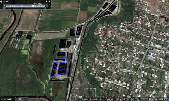
AidData provides spatial analysis training and applied experience to over 100 undergraduate research assistants annually, building a cohort of student analysts that can rapidly respond to answer pressing questions. Hannah Dempsey (a 2016 graduate of the College of William and Mary) was one such student who answered USAID’s call. In Armenia’s Ararat Valley, a decade-long explosion in commercial fish farming had improved livelihoods, but at a cost: by 2016, severe reductions in groundwater level had left 30 communities in the valley without reliable access to water, threatening the viability of the country’s main agricultural hub.
Working remotely on William and Mary’s campus in Williamsburg under the mentorship of AidData’s Chief Geospatial Scientist Dan Runfola, Hannah used Google Earth to delineate the physical footprint and water consumption of the valley’s commercial fisheries. Her analysis allowed the USAID/Armenia Mission to understand the full scale of the problem and begin to pursue solutions.
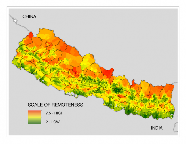
The following summer, Hannah again partnered with USAID — this time in the field as an AidData Summer Fellow. At the USAID/Nepal Mission in Kathmandu, she worked with the Mission’s GIS specialist to quantify remoteness throughout the country. By weighting, combining, and scaling dozens of relevant variables, she built a scale of accessibility that the Nepal Mission is now using to assess whether their programs are reaching Nepal’s most vulnerable populations.
The GeoCenter has helped opened the doors to summer fellowship opportunities for dozens more William and Mary students, working with AidData to place them in seven USAID Missions around the world since 2013. Adding high value to one Mission’s work, a Fellow embedded with USAID/Peru in 2015, Alex Kostura, was able to georeference all of their active projects for the first time.
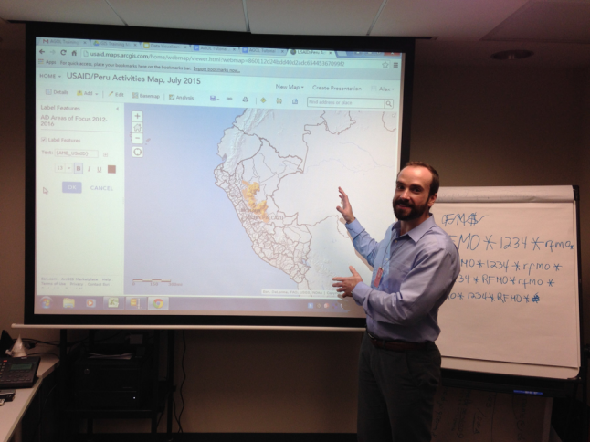
“Alex made tremendous progress on solving a mapping problem that the Mission has had for a long time,” said Marion Adeney, the Environmental Science Advisor and AAAS Science Fellow at USAID/Peru. “Everyone who has seen his work has gotten excited, and I am sure the new Mission director is going to be pleased.” As a result, USAID/Peru decided to host AidData Summer Fellows the following two years to build on the work and institutionalize geospatial analysis in the Mission.
Mining malaria data for Mozambique in Metro D.C.
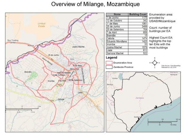
Benefits accrued for USAID closer to home as well. AidData placed Leigh Seitz (a 2017 graduate of William and Mary) with the GeoCenter in Washington, DC for a summer internship in 2016. Leigh worked on helping the President's Malaria Initiative (PMI) better target limited indoor residual spraying (IRS) resources in Mozambique. IRS requires that 80% of buildings within an area be sprayed to be effective — yet in Mozambique, earlier IRS efforts had lacked enough granular data to cover all residential houses.
From half a world away, Leigh used OpenStreetMap to tag all houses in two targeted districts by IRS status, enabling PMI to pinpoint exactly the houses that required spraying in upcoming IRS efforts.
For Leigh, the experience reinforced the power of mapping to improve service delivery. “By putting that location and those inhabitants ‘on the map,’ you are helping to more easily provide aid and, in my case, malaria prevention treatment methods, to their household,” she said.
For five years, the GeoCenter has served as a critical bridge between AidData and USAID by navigating USAID’s sometimes complex bureaucracy to identify unmet spatial analysis needs, and connecting those needs with capable William and Mary students. In turn, those students gain access to direct policy experiences often unavailable to undergraduates and have an impact on their hosting organizations that lasts long beyond their tenure.
Reflecting on AidData Fellow Joshua Okafor’s work at USAID/Rwanda, Acting Deputy Program Office Director Tom Targos recalled how Josh helped build a new user community at the Mission that can use GIS software to create maps and plan development activities, now and into the future. “Through Josh's work, the Mission has built a good foundation in the understanding, use and benefits of GIS mapping in development work — it is a foundation we plan to sustain.”