Every year, an increasingly diverse set of countries, international institutions and private foundations spend billions of dollars with the goal of improving the lives of citizens in developing countries. Donors, governments, civil society organizations and taxpayers alike hope to see large gains as a result of these investments – more stable, just and prosperous societies that are contributing as responsible members of a thriving international community. Is development assistance capable of achieving these aspirations? The answer hinges upon how decisions are made, with what information and who is involved in the process.
Information on both development inputs (i.e., who is spending what and where) and outputs (i.e., the results of those investments on the ground) should be a powerful asset in delivering better governance and more effective aid for developing countries. With the right information at their fingertips, governments can make evidence-based decisions to plan for their country’s future, citizens can hold their leaders to account for providing public goods with these funds and donors can invest aid dollars to yield the greatest possible results.
More often than not, however, donors and governments find themselves inundated with information buried in documents or frustrated by data silos between organizations and departments. Citizens, whether in countries giving or receiving development assistance, are also often stymied to make sense of aid information if it is not relevant, timely and easy to understand with minimal effort.
Localized information at a district, village or street corner level is more relevant and useful to a donor, civil society group or district government seeking to track aid flows relative to need and to identify gaps in service delivery. Since 2009, AidData has collaborated with numerous donors and governments to pinpoint the geographic locations of development projects in order to create maps and dashboards that anyone can use to visualize project activities and financial flows in the communities of greatest interest to them.
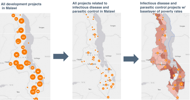
Mashing up data layers enables us to gain new insights into the relationship between aid and development indicators. The far left map visualizes the subnational distribution of aid projects throughout Malawi. The middle map shows the subset of aid projects related to infectious disease and parasitic control in the country. The far right map compares the distribution of these specific health investments with a base layer of poverty rates. Darker shades of red indicate higher rates of poverty per district. Source: aiddata.org.
It takes substantial effort – both human and financial – for donors and governments to geocode their development portfolios, make this information available to the public and ensure that this data is used and sustained. This raises the question: does geocoded data change the way that donors, governments and citizens consume information and make decisions? If so, how?
Tilak Bhandari, an official with Nepal’s Ministry of Finance, provides one poignant example. In generating several maps for its 2012 Development Cooperation Report, the Ministry discovered that too many donors were focusing in the same geographic areas and sectors, while one of the poorest regions of the country was receiving less assistance. “We didn’t know about [aid] fragmentation before, [but] now we have evidence,” said Bhandari. The Ministry of Finance was able to use this information to identify gaps and engage in constructive dialogue with international donors in order to bolster aid to Nepal’s Far Western Development Region. USAID Nepal has also integrated this geocoded development finance data into the preparation of its Country Development Cooperation Strategy.
A growing number of donors and governments are publishing open aid information and geocoding their development portfolios. Simultaneously, improvements in Internet penetration and the proliferation of mobile phones are enabling a broader set of development actors, including local civil society groups, universities and citizens, to access this spatial data and create their own maps analyzing who is funding what and where in their countries.
These are important steps forward, but there is more to do. Too many donors still do not publish detailed information on development projects that include geographic locations at a local level. Development mapping initiatives have not yet systematically integrated local data from citizens as they monitor the inputs of aid investments and outcomes of development activities in their communities. As private foundations and emerging donors are contributing a growing share of development assistance, it will be important to integrate these new financial flows when considering the total resource envelope available to countries. In the coming years, the development community will need to tackle each one of these challenges related to spatial information.
In the meantime, AidData is attempting a few small steps forward. We are developing improved functionalities on aiddata.org that will enable any user to directly upload and tag information on aid projects and locations. We have assembled the world’s most comprehensive database on Chinese development assistance to Africa (china.aiddata.org) and will begin geocoding these projects later this year. We will continue to build the capacity of donors, governments and civil society organizations to systematically incorporate geocoding within their work and contribute to ongoing discussions about improving data standards and quality.
